
The Different Types of Land Surveys Explained
 The most common types of land surveys are boundary, topographic, ALTA/NSPS, elevation certificate, construction staking, as-built, and subdivision surveys. Each one has a different job. The right survey for you depends on your project, your budget, and whether a lender or title company asks for one.
A land survey takes the legal description in your deed and shows it on the ground. A licensed surveyor measures your property, marks the corners, and creates a map.
What is a land survey?
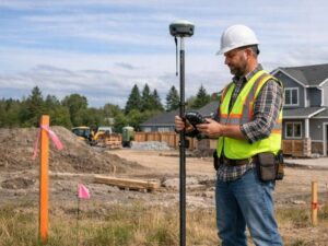
A land survey is a professional measurement of a property done by a licensed surveyor. It sets the legal boundaries, finds physical features, and records elevations. All 50 U.S. states require a license to do this work. A boundary that is measured by someone without a license has no legal standing.
Surveyors mix two kinds of work. First, they research records like old deeds, plats, and past markers. Second, they take field measurements using GPS, total stations, and sometimes drones. The final result is usually a map that the surveyor signs and stamps. Because each project is different, the wrong survey wastes money, and the right one can save you from problems later.
What are the main types of land surveys?
Most property owners deal with seven survey types: boundary, topographic, ALTA/NSPS, elevation certificate, construction staking, as-built, and subdivision. Boundary surveys are the most common for homes. ALTA surveys are the most detailed and are used for business deals.
Boundary survey
A boundary survey finds the legal edges of your land. The surveyor locates the corners, measures the distances, and places markers, which are usually iron rods topped with bright pink or orange tape. This survey shows where your land starts and stops and whether anything crosses the line.
You need one when you sell property, put up a fence, or settle a question about where your land ends. A standard home lot usually costs between $375 and $900. Larger or oddly shaped parcels cost more.
Topographic survey
A topographic survey maps the shape of the land. It records the slopes, contour lines, drainage, trees, and any buildings. Engineers and architects use this data to design homes, grading, and drainage systems.
This survey is best before any construction or grading project. A home lot often costs between $500 and $1,200. Bigger or more complex sites can run from $1,000 to $3,500 or higher.
ALTA/NSPS survey
An ALTA/NSPS survey is the most thorough survey in the country. Two national groups set its rules: the American Land Title Association and the National Society of Professional Surveyors. It blends boundary work, terrain detail, and title research into one document. It also shows easements, encroachments, utilities, and access rights.
This type is best for commercial property and for deals where a lender or title insurer requires it. It usually costs from $2,000 to $6,000 or more, depending on the size and difficulty of the property.
Elevation certificate
An elevation certificate is a FEMA form that records how high a building sits compared to the expected flood level. Insurers use it to set flood insurance prices. If a property was wrongly placed in a high-risk zone, this form can lower the premium by a large amount.
You need one if your building is in or near a flood hazard area. A typical home costs between $175 and $500.
Construction staking survey
Construction staking turns building plans into real markers on the ground. The surveyor places stakes that tell the crew exactly where to build foundations, utilities, and roads. This keeps the finished work lined up with the design.
It is best during active building projects. The cost changes a lot based on the size of the job, so it is often priced by phase.
As-built survey
An as-built survey records what was actually built after the work is done. It confirms that the finished structures match the approved plans and notes any changes. Many cities require this survey before they will issue a certificate of occupancy.
It is best for closing out permits and confirming finished work. The price is usually similar to a topographic survey and depends on the scope.
Subdivision survey
A subdivision survey splits one large parcel into smaller lots. The surveyor draws new boundary lines inside the original tract and creates a plat that can be officially recorded. Developers and landowners use it when they want to divide property for sale or building.
The cost varies widely because it depends on the number of lots and the rules in your area.
ALTA survey vs. boundary survey: what is the difference?
A boundary survey finds property lines and corners and is used mostly for homes, fences, and sales. An ALTA/NSPS survey does all of that and adds title research, easements, encroachments, and utility data. It follows national rules and is usually required for business deals. In short, an ALTA survey is a boundary survey with much more detail.
Feature | Boundary Survey | ALTA/NSPS Survey |
Main purpose | Find property lines | Full title-grade survey |
Rules | Set by each state | National standards |
Common use | Homes, fences, sales | Commercial deals |
Title research | Not included | Included |
Typical cost | $375 to $900 | $2,000 to $6,000+ |
Which land survey do I need?
Pick a boundary survey to confirm property lines or build a fence. Pick a topographic survey before you build. Pick an ALTA survey for a business purchase or when a lender asks for one. Pick an elevation certificate to set flood insurance rates. If you are unsure, describe your project to a licensed surveyor and ask.
Here is a quick guide:
- Buying a home lot? Start with a boundary survey.
- Planning to build? Add a topographic survey.
- Buying commercial property? You likely need an ALTA survey.
- Worried about flood insurance? Get an elevation certificate.
- Splitting a parcel? Order a subdivision survey.
- Finishing construction? Get an as-built survey.
Frequently asked questions
How long is a land survey valid?
There is no set expiration date. A survey shows the conditions on the day it was done, and that record can stay useful for many years. Still, lenders and cities often want a survey from the last 5 to 10 years. You will need a new one if the land or its buildings have changed.
Do I legally need a survey to buy property?
It is not always required by law, but it is a smart move. A survey confirms you are buying what you think you are buying. It also reveals problems before closing. Lenders and title insurers often require one anyway.
Can I survey my own property?
No. In every state, a valid boundary must be set by a licensed surveyor. Measurements you take on your own have no legal standing if a dispute comes up.