
How to Read a Property Survey: A Simple Guide to Plats, Bearings, and Symbols
 To read a property survey, start with the north arrow to learn the direction, then check the scale to understand distances. Find the bold lines that form your property boundary, read the numbers and bearings along each line, and use the legend to decode the symbols. The corner markers, notes, and seal complete the picture.
A property survey can look like a confusing page of lines, numbers, and symbols. But once you know what each part means, it becomes easy to read. A survey is a map of your land that a licensed surveyor signs and stamps. It shows your boundaries, your corners, and the features on your property. This guide walks you through each part of the page.
What is a plat?
A plat is a drawn map of a parcel of land. It shows the shape of the property, the boundary lines, the corners, and often nearby lots and roads. A surveyor creates it from field measurements and records. Plats are filed with the local government and are used for building, zoning, and clearing up boundary questions.
A plat is the picture version of your land. While your deed describes the property in words, the plat shows it as a drawing. The two work together. The plat helps you see the shape and size of your lot, where the corners sit, and how your property relates to the land around it. Now let us look at how to read each part.
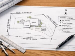
Start with the north arrow and the scale
The north arrow shows which way the property faces, so you can line up the map with the real world. The scale tells you how distance on paper compares to distance on the ground. For example, a scale of one inch equals one hundred feet means every inch on the map stands for one hundred feet of land.
These two items are the foundation for everything else. Find the north arrow first, usually in a corner of the page. It points you in the right direction so you can match the drawing to your actual lot. Then find the scale. Without it, the lines on the page would have no real meaning, because the scale turns the drawing into true measurements you can picture on your land.
Find the boundary lines and the corners
The boundary lines are the bold lines that form the outer shape of your property. The corners are the points where these lines meet, and each one is usually marked on the ground with a physical marker called a monument. Together, the lines and corners show exactly where your land begins and ends.
The boundary is the most important part of the survey. It is drawn as a heavy outline near the center of the page. The shape may be a clean rectangle, or it may be irregular if your lot follows a road or a creek. At each corner, the surveyor places a monument, often an iron rod or a concrete marker set into the ground. On the map, monuments appear as small symbols, such as a solid circle for a marker that was found and an open circle for one that was newly set. A metal detector can help you locate iron rods in your yard.
Read the bearings and distances
Each boundary line has two numbers. The distance tells you how long the line is in feet. The bearing tells you the direction of the line using compass angles, written in a form like N 45 degrees 30 minutes E. Together they let you trace the exact path of each property line.
Bearings can look strange at first, but the idea is simple. A bearing like N 45 degrees E means the line points northeast at a 45 degree angle. The smaller units, called minutes and seconds, make the direction more exact. The distance number next to it, such as 150 feet, tells you how far the line runs. When you read these in order around the property, you trace the full shape of your lot. This written path is also called a metes and bounds description. “Metes” means the distances, and “bounds” means the directions.
The reading starts at the point of beginning. This is a fixed, easy-to-find spot, such as a road intersection or an older survey marker. The surveyor begins there, follows each bearing and distance around the land, and returns to the same point to close the shape. Closing at the start is how the surveyor confirms the boundary is complete. If the lines did not return to the start, there would be an error.
Use the legend to read the symbols
The legend is the key that explains every symbol, line type, and abbreviation on the page. Solid lines often mean boundaries, while dashed or dotted lines may mean easements or setbacks. Never guess what a symbol means. Always check the legend first.
The legend is your decoder. A survey uses many different lines and marks, and each one has a meaning. Bold solid lines usually show your property boundary. Dashed or dotted lines may show easements, utility lines, or required building setbacks. Other symbols may mark trees, fences, driveways, or buildings. Because mapmakers can use slightly different symbols, the legend on your survey is the only reliable guide. Reading it first saves you from costly mistakes.
Check the notes and the surveyor’s seal
The notes section holds important details like the survey date, legal disclaimers, and any conditions that affect the property. The seal includes the surveyor’s signature, license number, and the date. Together they confirm the survey is official and show how current it is.
Do not skip the small text in the corners and margins. The notes may flag special conditions, reference points, or items that affect how you can use the land. The survey date matters too, because boundaries and features can change over the years. The surveyor’s signature and license number prove a licensed professional prepared the document. If anything is unclear, the surveyor’s contact details are usually listed so you can call and ask.
Frequently asked questions
What is the difference between a plat and a survey?
A survey is the act of measuring and the resulting drawing of a specific property. A plat is a recorded map, often of a whole subdivision, showing many lots, streets, and shared areas. A plat is filed with the local government, while a survey can be done for a single parcel at any time.
Who can answer questions about my survey?
The surveyor who prepared it is the best person to ask. Their name, phone number, and license number are usually printed on the page. They can explain any symbol, walk you through the bearings, and help you find your corner markers.